
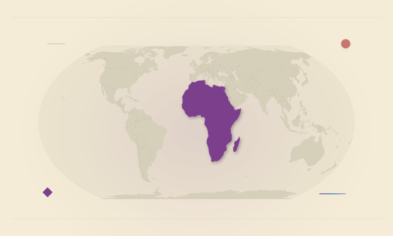
The United Nations General Assembly voted on Friday, 4 September 2026, to endorse equal-area world maps over the centuries-old Mercator projection.
The “Correct the Map” resolution, tabled by Togo on behalf of the African group, passed with 164 votes in favour, six abstentions. Only one country voted against the change: the United States.
The resolution is non-binding. It encourages governments, schools, international organisations and technology companies to adopt equal-area projections whenever relative size matters, and names the 2018 Equal Earth projection as its example. It also asks that pupils be taught that every flat map of a round planet distorts something.
The cartographic illusion
Gerardus Mercator designed his projection in 1569 as a navigational tool for sailors. It keeps compass bearings as straight lines, useful at sea and useless for comparing countries. It stretches land near the poles, so Greenland appears roughly the same size as Africa. Africa is about 14 times larger. The campaign behind the resolution puts it another way: the United States, China, India, Japan, Mexico and most of Europe fit inside Africa with land to spare.

The geopolitics of geography
Africa No Filter and Speak Up Africa lead the campaign, and it secured the African Union’s endorsement in August 2025.
“A fair map does not change the geography of the world, it changes how we see the world,” Togo’s foreign minister, Robert Dussey, told the Assembly. Togo says it will overhaul its school geography materials by the end of the year.
On the morning of the vote, French foreign minister Jean-Noel Barrot announced that France would drop Mercator for its official maps.
America
Mike Waltz, the US ambassador to the UN, dismissed the resolution as part of “the much larger and more radical ideological project”. The US said the debate distracted from “genuine problems of international peace, prosperity or good relations”.
Estonia, Georgia, Lithuania, Moldova, Serbia and Ukraine abstained. Ukraine’s envoy, Andriy Melnyk, said his concern was how disputed territories are drawn on official maps.
A 164 to 1 tally on a non-binding resolution changes no policy anywhere. What it shows is what a US no at the UN costs in 2026: practically zero. Nobody joined Washington, and France, a NATO ally, championed the other side. The same thing happened when the US imposed a 10% tariff on Kenyan goods in April 2025: Washington still acts, but it acts alone, and the rest of the room works around it.
The map most Kenyans actually look at is Google Maps or Apple Maps. Google’s own developer documentation says the Maps SDK for Android, like Google Maps on the web, uses the Mercator projection. Google did add a globe view on desktop for users who zoom all the way out in 2018, so a fix exists. But the resolution can only “encourage” technology companies. It cannot compel them, and the General Assembly has no vote over product decisions made in Mountain View or Cupertino.
Whether this changes anything for a Grade 7 pupil in Nairobi depends on two things neither Togo nor the UN controls: whether Google and Apple change the zoomed-out view in their mobile apps, and whether Kenya follows Togo and rewrites its geography textbooks. Togo has given itself until December.






Join the discussion